Exploring the Lost Land Beneath the North Sea
New research reveals that Doggerland—a sunken swath of Europe connecting Britain to the mainland—was more than a simple thoroughfare. It was home.
This story was originally published at Hakai Magazine. It appears here under a Creative Commons license.
The North Sea is a hard place to love. It’s not the cold, or the silty gray-brown waters that seem to suck the brightness out of the sky that make it unappealing, it’s what people have done to it over the centuries, transforming the North Sea into an industrialized seascape.
Trade has made this sea—which washes against the United Kingdom to the west and mainland Europe to the east—one of the world’s busiest shipping lanes. Some 1,300 passenger ferries, cargo vessels, and tankers cross the English Channel at the sea’s narrowest point every week. Commercial trawlers harvesting cod, herring, haddock, and more have scoured the seabed, causing some fish populations to decline. The fossil fuel industry has sucked 45 billion barrels of oil and gas from the bedrock beneath the United Kingdom’s territorial waters alone over the past half-century, leaving the rusting remnants of abandoned oil rigs rearing from the sea’s turbulent surface. Above the waves, the North Sea hums with dozens of wind farms, with many more to come, each one comprising hundreds of towering turbines to generate electricity and replace dwindling reserves of fossil fuels. And all this human exploitation has polluted the sea with undesirable chemicals, trash, and noise.
Once upon a time—before industrialization—the sea was filled with life. But go back further still, and the land beneath the sea itself was a vibrant ecosystem for all manner of terrestrial beings.
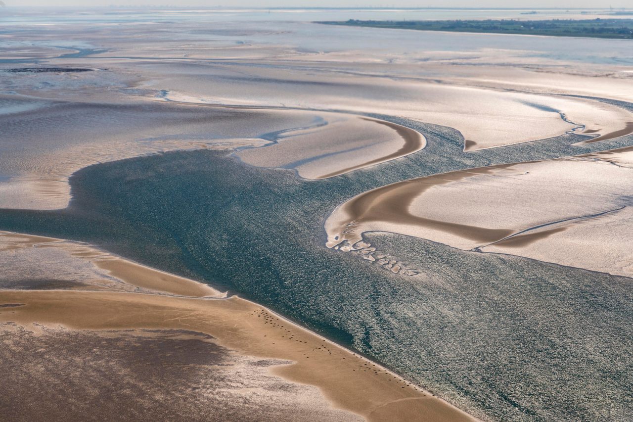
Evidence of the earliest human use of the North Sea region lies deep beneath the water, suspended silt, and seafloor, in the submerged territory of Doggerland that once connected the United Kingdom and mainland Europe. Before Doggerland was lost beneath rising seas, its low hills and broad valleys, braided rivers and wide estuaries, marshy wetlands and long gravel beaches were home to bear, boar, red deer, and people.

Doggerland is not well known outside the field of archaeology. And historically, when archaeologists have discussed it, they considered it a land bridge connecting two more interesting places, used by people to travel between Europe and modern-day Britain around 12,000 years ago. But innovative archaeology is reframing Doggerland as a territory in which human communities lived and thrived for millennia—a place that was known, that was home to generations—until a warming climate and rising seas forced people to leave and it was forgotten. As climate change accelerates in the modern era, the story of Doggerland becomes a story of our future.
Vincent Gaffney, a jovial and unpretentious 66-year-old landscape archaeologist with close-cropped white hair and thick dark-rimmed spectacles, has spent two decades conjuring this lost land from the murky depths. Unlike most archaeologists, Gaffney has conducted his explorations without ever setting foot on his study site, which lies roughly 60 to 100 feet below the sea’s surface. Instead, his pioneering work at the Submerged Landscapes Research Centre, which he founded at the University of Bradford in England, involves sifting through huge quantities of seismic survey data. The detailed 3D maps and simulations he derives from that data re-create the topography and ecological complexity of an area nearly the size of Washington State. His work disputes the dismissive assumption that Doggerland was simply an ancient thoroughfare by bringing into relief a place that was ideal for human habitation, with all the water, food, and other resources people would have needed to thrive. “Everyone called it a land bridge, something you come across or go back again,” he says. “But you don’t live on bridges.”
Gaffney was born to working-class parents in England’s northeast and, despite spending a lifetime in the rarefied world of academia, retains his gentle Geordie burr and a love of English ale. For half his career, he has been beguiled by Doggerland, the idea of a lost landscape, of an Atlantis beneath the North Sea. But Doggerland is not Atlantis; it is not even that unusual.
The world has many submerged ancient coastal shelves such as Doggerland: Beringia extends between North America and Russia; Sundaland underpins Southeast Asia; the Sahul Shelf juts out from Australia. “Coasts hold the key to the mobility of humans across the millennia,” Gaffney tells me over a pint and a pie at his favorite pub. Cumulatively, submerged coastal shelves take up about the same space as present-day North America and would have been fundamental territories for human occupation and migration. Yet they have been largely out of reach of archaeologists. “These are all massively important historical areas which you cannot understand unless you know what’s happening underneath the sea,” Gaffney says.
What makes Doggerland different from Earth’s many other submerged lands is that Gaffney has found a way to see it.
By mapping the prehistoric land beneath the seabed and pioneering techniques for finding artifacts, Gaffney is also opening up the world’s other submerged continental shelves to remote archaeological exploration. Researchers in the Baltic Sea, elsewhere in the northern hemisphere, and in Australia, for example, are adopting his approach. The hidden coastal shelves represent a world of human habitation lost as the ice sheets began their retreat 20,000 years ago, triggering a global sea level rise of more than 394 feet. The global flooding that followed the last ice age “was the last time that humans experienced climate change at the scale we’re talking about now,” Gaffney says.

Long before Gaffney began using technology to construct renderings of Doggerland, the submerged landscape was releasing clues about its existence in shards and fragments. Victorian-era oyster dredgers and trawlers occasionally hauled up the bones of mammals such as wolves, bears, elk, reindeer, woolly mammoths, and woolly rhinoceroses, along with lumps of peat known as moorlog. The fishermen commonly tossed the bones into deeper waters to prevent them from tangling nets, but some of the bones made their way into private collections and small museums. And for the past half-century, beachcombers and hobbyists searching the coastal and intertidal zones have collected harpoon tips, flint shards, and mammal bones, as well as fragments of human skulls, femurs, and jaws—and even a spearhead made from human bone—some of which have been dated back to Doggerland.
In the early 1900s, geologist and paleobotanist Clement Reid became intrigued by another mystery emerging from the sea. Stumps of drowned trees sometimes appear at very low tides along parts of the English coast. Confounded 19th-century visitors surmised they were seeing proof of divine intervention and nicknamed the stumps Noah’s Woods. In his 1913 book Submerged Forests, Reid proposed that the trees, mammal bones, and peat—which contained preserved bogbean seeds, willow leaves, and birchbark—were all evidence of a “sunken land.” He envisioned fen and forest stretching far beyond the coastline deep into the North Sea. Reid theorized that the Dogger Bank—a submerged sandbank roughly in the middle of the North Sea and named after Dutch fishing boats known as doggers—“once formed the northern edge of a great alluvial plain, occupying what is now the southern half of the North Sea, and stretching across to Holland and Denmark.” Gaffney considers Reid’s book foundational in arguing for the importance of submerged lands in prehistory.
Vindication of Reid’s argument came in 1931, when a trawler skipper split a piece of moorlog that was clogging his net and discovered a delicate nine-inch-long spearhead. It was finely crafted from red deer antler, notched with sawtooth barbs, and carved with a series of parallel incisions. Archaeologists later determined this artifact—the first human tool from the North Sea studied—to be 13,000 years old. Sufficient numbers of similar barbed points have been found at numerous sites along the North Sea coast that they are considered a typical technology of the Mesolithic and Upper Paleolithic European time periods between 50,000 and 6,000 years ago. The spearheads were likely used by shoreline, estuary, and riverine people to hunt fish in the shallows. British academic Grahame Clark devised a theory of human migration based partly on that spearhead discovered in 1931; in it, he characterized the region that later became known as Doggerland as a land bridge (though the term would come later), and the reputation stuck.
Archaeology grew as a new discipline through the 20th century, yet there was so much to explore on land that looking beneath the sea hardly seemed a worthwhile pursuit. Doggerland, only just glimpsed, slipped from view. Artifacts continued to turn up, but these chance finds, collected and catalogued by museum curators, lacked the context for anyone to make sense of them.
The scientist who turned attention back to the North Sea was Bryony Coles, a professor emeritus of prehistoric archaeology at the United Kingdom’s University of Exeter, who published a seminal, if esoteric, paper titled “Doggerland: a Speculative Survey” in 1998. In the paper, Coles reinterpreted existing discoveries and literature. The general consensus among archaeologists at that point was that Doggerland was too difficult to study because it was underwater and unimportant because it was a thoroughfare. Coles reframed it as a place of significance. The artifacts were, she wrote, reminders that “the area of the present North Sea has been land in the past, and land that people knew.” Her paper gave Doggerland its name and its first tentative, theoretical maps consistent with what Reid had proposed. “Instead of focusing on land as bridge, we focus on land as a place to be,” she wrote. Doing so meant reinstating an erased people in both time and place, and restoring a lost history. Coles reframed Doggerland as a vast, populated plain that was the heartland of northwest Europe.
Coles changed the way archaeologists thought about Doggerland, but what kind of “a place to be” was it? That question would set Gaffney off on a decades-long quest for answers.
As Coles drafted her paper on Doggerland’s watery past, Gaffney’s feet were firmly on dry ground. In the 1990s, he was experimenting with using GIS to conduct a kind of noninvasive archaeology that explored larger areas than could practically be excavated by hand. One of his early projects showed the hidden extent of a Roman city in Shropshire, in the west of England. He used similar techniques to map the landscape surrounding Stonehenge, the 5,000-year-old stone circle that is perhaps the most famous archaeological site in Britain.

At England’s University of Birmingham in 2001, Gaffney was teaching a postgraduate seminar on places that lie beyond the reach of archaeologists—“landscapes we could do nothing with,” as he puts it—when the North Sea came up in discussion with a graduate student named Simon Fitch who had previously studied geology. They wondered whether 3D seismic data collected for fossil fuel exploration could be used to create a detailed topographical map of the unseen landscape beneath the waves, but the question seemed moot. “The problem was, which oil and gas company would talk to us?” says Gaffney.
Seismic surveys of the ocean are carried out by boats: they emit sound waves toward the seabed, and hydrophones record the seismic waves that reflect off and travel through the different materials beneath the surface. The surveys cost tens of millions of dollars per project and result in an X-ray image—a 3D picture of rock types, stratigraphy, and sediments that help identify potential crude deposits. The use of the technique is a worthwhile investment for multinational oil companies but is far beyond the budget of ordinary archaeology departments.
Gaffney and Fitch needed an introduction. They convinced a colleague who had experience working in basin geomorphology for the oil industry to help; together, they visited Petroleum Geo-Services (PGS), which acquires seismic data and compiles it into what it calls “MegaSurveys.” The company agreed, free of charge, to provide some data with which Gaffney and Fitch could attempt to create a prototype map, with the caveat that it would be “not very much, only 2,300 square miles.” Gaffney was stunned: his survey of Stonehenge, the largest archaeological geophysical survey in Britain at the time, had covered less than 6 square miles.
Gaffney used a bank of powerful computers to process the data, projecting the images onto a home cinema-sized stereoscopic screen, which he viewed through a pair of retro-futuristic wraparound 3D glasses. It took months, but gradually the land emerged on the screen, creating a portal to a lost world. The seismic data “took us deep into the Paleolithic,” he says. The images revealed the contours and outlines of ancient valleys beneath 12,000-year-old rivers. It was proof of concept that seismic data can be used to expose submerged lands. PGS donated another 7,300 square miles of data. The thin 100- to 130-foot top layer interested Gaffney most because it corresponds to the period when the glaciers were melting. European ice sheets had retreated northward over thousands of years as temperatures rose. Glaciers gave way to barren, windswept tundra and permafrost. Then, rivers and streams, lakes, estuaries, salt marshes, hills, and valleys began to appear, transforming the land into an ecosystem where people would have been able to survive in Doggerland for the first time as the warmer geological epoch of the Holocene began 11,700 years ago.
Armed with his new 3D visualizations, Gaffney plunged headlong into Doggerland, eager to seize the opportunity to discover this long-forgotten landscape. His ultimate goal is to determine where and how the people of Doggerland lived. Over the years, he has amassed astonishing quantities of seismic data, using it to expand and add detail and texture to his maps. With the maps, he has been able to identify where plants and animals likely lived, edging him ever closer to finding direct evidence of human habitation, such as settlements, houses, pits made for ritual or domestic purposes, or dense collections of animal bones or flint tools. He has rented research vessels to conduct high-resolution 2D seismic surveys that measure in inches instead of feet to add even more detailed information to the maps; deployed submarine cameras and mechanical dredges to bring up samples of seabed deposits; and extracted nearly 100 sediment cores, which have provided a wealth of information. Each core is collected by driving a four-inch-diameter tube deep into the seabed. The extracted cylinder of peat, sand, chalk, and other material can then be radiocarbon dated, slice by slice, and read as a timeline of dynamically shifting habitats. The cores also contain ancient environmental DNA that can be analyzed to show what lived on the land.
The work has involved occasional seasickness. And endless funding bids. Gaffney has managed to carry out such an extensive investigation of Doggerland, running a series of collaborative projects for the past 20 years, because a wide range of sources have supported the work. The UK government, the US National Oceanic and Atmospheric Administration, and the European Union are among his funders. His most recent grant is the biggest yet: a European Research Council-funded project called SUBNORDICA for investigating the entire southern North Sea and parts of the Baltic Sea, worth €13 million (US $13.7 million). “In archaeological terms, it’s like we’ve robbed a bank,” says Gaffney.
He focuses on estuaries and rivers, such as the submerged Southern River, 19 miles off the eastern coast of England. It was a waterway that sprang from peat soil, cut through a chalk outcrop, and drained into a large estuary—precisely the kind of place where people would have congregated and where sediments accumulate. Robin Allaby, an evolutionary geneticist at Warwick University in the United Kingdom, has taken hundreds of teaspoon-sized samples from Gaffney’s sediment cores and sequenced the DNA in each one. “The bottom of the sea is basically a constant four degrees [Celsius]—more or less a fridge—which is ideal [for preserving organic matter],” he says.
Allaby’s samples contain 574 taxa of plants and reveal rapid colonization by plants, with a leap in biodiversity just before the start of the Holocene. The Southern River, for example, was characterized by marshland and seagrass at the estuary, rising into grassland and deciduous woods that were predominantly willow with alder, elm, hazel, wingnut, and oak. By the Holocene, Doggerland was “basically a northern temperate forest biome,” Allaby says, “a very inhabitable landscape,” full of resources and opportunities for humans.

Doggerland’s low-lying mosaic of fish-rich waters, wetlands, hills, and animal-filled woods was an ideal environment for foragers who thrived where food sources were diverse. So far, little is known of the lifestyles of Doggerland’s inhabitants, but there is plenty of evidence from today’s coastal Mesolithic sites in the United Kingdom and Europe, areas that were the outer reaches of Doggerland before its inundation between 20,000 and 7,500 years ago. Here, people lived in small bands or larger communities; made tools from stone; felled wood for fuel and construction of simple houses; foraged plants, nuts, and seeds; caught fish in rivers and the shallow sea; and hunted animals, butchered them for food, and used their skins for clothing and their bones and antlers for fishing harpoons, weapons, and ritual objects. When faced with scarcity, mobility is the fundamental survival strategy for foraging people, but when resources are plentiful, they stay put. Archaeologists have found Mesolithic settlements, as well as burial sites, all around the North Sea’s present-day coastline, which suggests the only reason they have not found them in Doggerland is because those sites are beneath the sea. Gaffney aims to fill this archaeological lacuna.
Doggerland was a land of plenty, but it was dynamic too, and this would eventually prove catastrophic. Within 14,000 years of emerging from the ice, Doggerland was submerged. Its gradual inundation is documented in the marine sediment and in the DNA, which shows that salt marshes crept ever farther up the freshwater Southern River over time.
At the University of Bradford, Gaffney’s colleague Phil Murgatroyd feeds all of this astonishing detail into a computer simulation that allows users to navigate a changing landscape over time, observing the interactions of plants, animals, and people. The data, says Gaffney, is “the backdrop, but the real output is visualization.” Murgatroyd’s model is the gamification of science: complex data that looks like Minecraft’s blocky 3D world and is navigated using an Xbox controller.
“These landscapes were named and loved”—just like the places people live in and know today—says Gaffney, “and climate change destroyed that. We should be aware of that, and we should have a better relationship with these landscapes. Phil’s work is the start of humanizing that landscape.”
Gaffney’s team at the University of Bradford is also analyzing a new set of sediment cores and other material collected in 2024, hoping to find traces of human presence, activity, or even settlement. Inspired by the search for extraterrestrial life on planets where conditions are not too hot and not too cold but just right, Gaffney has used his maps and the analysis of sedimentary DNA to zoom in on specific areas where people most likely had the right conditions to thrive, targeting them for remote exploration. “To find something, we need to have a place where it exists, where it is preserved, and where it is accessible. That’s the Goldilocks Zone for doing archaeology in the North Sea,” he says. “Accessible” is the tricky variable when it comes to submerged landscapes beyond the intertidal zone.
Yet Gaffney and his colleagues are optimistic because they have succeeded before, says Simon Fitch, sliding a little takeout box across the table toward me. Nestled inside is a small fragment of a handworked flint dredged from the Southern River in 2019. The team had lowered a mechanical grapple 98 feet to the seafloor and dug to a depth of about four inches to find it. Dark and shiny on one side where it was buried, rusty red on the exposed side, the flint is smooth and light with beveled edges and fits neatly in the palm of my hand. “It’s the edge of a hammerstone,” Fitch says with a grin, “the first directly prospected find from the North Sea.” Fitch explains that hammerstones were used in the manufacture of other simple stone tools, such as sharp flakes for cutting, and that this one was found close to a chalk cliff, which “suggests guys were going there to tool up.” The site may have been a kind of stone tool factory.
Until now, archaeologists have only ever found artifacts from far out at sea by chance—caught in a net or washed up on a beach—so the hammerstone is a breakthrough for archaeology and for Doggerland because it put people on the map and gave archaeologists reason to keep looking. “We had a landscape, we had dynamism, we had vegetation, but the thing that had been lost was the people,” says Gaffney. The flint changed that.
The approach of identifying a promising site and then hauling up material from a particular place is not the only technique being developed at the University of Bradford. In another room in the archaeology department, Gaffney’s colleagues sit at computers: Murgatroyd is working on his simulation; Ben Urmston explores the use of marine magnetometry to identify where people created structures such as fire pits or post holes; and Andrew Fraser is training AI and running machine learning programs to sift through the immense and ever-expanding data sets.

The work of Gaffney and his colleagues has been pioneering, says Luc Amkreutz at the Dutch National Museum of Antiquities who, in 2021, curated an exhibition of Doggerland’s many found artifacts and edited the book that followed. “It is tremendously important as it creates an awareness of the existence of a past landscape by resurfacing it, texturizing it, materializing it with rivers, lakes, hills, marshes, and coastline,” he tells me. “It creates a canvas for a populated world, the traces of which we document on our beaches and in our fishing nets.” To see Doggerland as a land bridge is to look at it from a narrow, contemporary perspective, constrained by present-day coastlines and modern settlement patterns. But to understand Doggerland as a lived and lost landscape is to consider it on its own terms.
One summer afternoon, I wade into the North Sea off the Norfolk coast and swim out a little way toward Doggerland. Out of my depth in the bracing sea, I imagine the seabed dry and planted firmly beneath my feet, the shore a low escarpment marking the farthest reaches of a familiar landscape. As Doggerland disappeared, the people living there would have slowly departed as their home became uninhabitable, venturing into a new, lesser-known land.
Unlike people today, early Holocene people lived within the limits of nature and the lands they inhabited: when resources were scarce, they adapted; when a changing climate caused sea levels to rise, they migrated to new lands. Faced with anthropogenic climate change, migration is, once again, a solution for those whose lives become unlivable, but in a crowded and unequal world, it is hard, contested, and political.
“The story of how Doggerland turned into the North Sea teaches us that we are vulnerable and that we are not above, but are dependent on, nature,” says Emilie Reuchlin, a Dutch marine biologist, political scientist, and cofounder of the Doggerland Foundation conservation organization. “It shows us how destructive climate change can be. Doggerland teaches us humility.”
As Doggerland was diminished by rising seas, the landmass shrank to become an archipelago, then a single island, before the last hilltop became the shallow Dogger Bank. By 6,000 years ago, this once varied, resource-rich land had flooded entirely, and the last of its human inhabitants had moved to higher land to the east and west.
Doggerland is a reminder that the world is not static, that the landscape we know today is different from what it was in the past and will not remain the same in the future. Doggerland’s disappearance is also a reminder of humanity’s reliance on and subordination to nature; its message is to adapt to, nurture, and protect the environments we depend upon.
With the landscape in this state of constant evolution, Gaffney worries about the past slipping out of view. An irony of his work is that Doggerland was revealed thanks to seismic data from the fossil fuel extraction that is driving the climate change that threatens us all. But the renewable wind energy crucial to reaching net-zero targets also threatens to put Doggerland out of reach forever, beneath a tangle of undersea cables, anchors, pilings, and safety exclusion zones that could make sampling and dredging impossible. Thousands of wind turbines are already operational, with many thousands more to come as Europe looks to the wind-whipped North Sea to generate more and more of its electricity.

Gaffney sees opportunity as well as threat in the wind energy infrastructure, however. Like the oil fields, wind farm developments produce tremendous quantities of new data about the geology of the shallow seabed as part of their site surveys. That information could deepen the understanding of Doggerland. Gaffney’s ambition is to persuade wind farm developers and national governments of Doggerland’s importance as a site of natural and cultural heritage, and to convince them of the need to share the data and allow archaeology to be carried out before new wind farms are built and access to the seabed is curtailed. “This is a time-limited opportunity to understand some of the last great unexplored [formerly] habitable landscapes on Earth, and we’re only just cracking the code,” says Gaffney.
Scientists expect global warming will cause sea levels to rise by up to three feet by 2100, and then will keep rising as temperatures continue to increase and ice sheets continue to melt. Coastal areas are highly populated today, as they were thousands of years ago.
The questions raised by the study of Doggerland, about how to adapt and survive when the climate changes, are being asked again in the 21st century. How many people called Doggerland home and how many were forced to migrate when their adaptive skills could no longer keep up with the pace of environmental change is not yet known, but today there are an estimated 190 million people living on land that will likely be underwater by the end of this century. How will we adapt? Where will we go?






Follow us on Twitter to get the latest on the world's hidden wonders.
Like us on Facebook to get the latest on the world's hidden wonders.
Follow us on Twitter Like us on Facebook